
|
|
|
|
BY: SUN STAFF
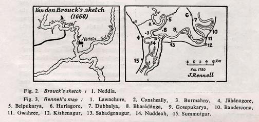
Fig. 2 & 3 Dec 04, 2010 — CANADA (SUN) — A paper by Professor K. N. Mukerjee, retired head of the Department of Geography, City College, Calcutta, in three parts. EXPLORERS SKETCH, SURVEYED MAPS, RECORDS, ETC. Van den Brouck (1660): Even a hundred years after Sri Caitanya, the sketch map of Van den Brouck showed Neddia near the confluence of the Ganges (Ganga) and the Galganse (Jalangi), but to the east of the Ganga and north of the Jalangi (Fig.2). As it is not a surveyed map, the distances and river forms (meanders) are not reliable. Yet the fact remains that the saw Nadia by the east of the Ganga and plotted it as such is acceptable. Rennell (1760): First systematic surveyed maps of Bengal were published by J. Rennell (1778-80). The Nuddeah area in Map No. 42/XI (Fig.3) gives clearly the layout of the rivers in late 18th Century and, the location of a few villages, road and Kishenagur (Krishnanagar) town as the headquarters of the newly constituted (1772) District of Neddia (Nadia). Most significant is the location of the small nucleus of the new Nuddeah (Navadvipa) town on the west bank of the heavily meandering Hoogly (Ganga) river. The location of some of the villages, present even now, is given e.g. Jahanagore, Summutgur (Samudragarh), Belpukaya, Bharadanga (i.e. the land created by the filling up of the Ganga, now known as Bharuidanga), Dubbalya (Dhubalia) etc. Old Janhunagar (the place of Saint Jahnu from which the Ganga was also named as Jahnavi) was Muslimized during the Muslim rule. Even new Navadvipa city was variously named as Kasimpur, Osmanpur etc. but these names did not stick to the city as the traditional name had great popularity. But afterwards when the old city decayed totally, some of its localities retained their pur or nagar names, even though turned into villages (as mentioned earlier). Of course, some such later villages, where Muslims (converted and/ or migrants) predominated, either retained the Muslimized names if given, or took new Muslim names. Gradually these names started appearing in British survey maps. Leaned old Ganga courses are also shown in Rennells map. The main flow of the river has been named south of Nuddeah as Hoogly afetr the Portuguese town Oegly on its bank further south. Ganga-govinda Singh (1785?): It is recorded that during the governorship of Warren Hastings (1772-85), Dewan (finance secretary) Ganga-govinda Singh got a map of newly formed Nadia District prepared, which was kept in the Collectorate at Krishnanagar till late in the British Period. The most significant feature of the map was the location of Mayapura by the NE of the confluence point of the Ganga and the Jalangi. Kedarnath Datta (Bhaktivinoda) as Deputy Magistrate and Collector of Krishnanagar Sub-division came across this map in 1887 and decided to search out the exact location of the place (Chatterjee 1915). Before Ganga-govinda got this map prepared, Narahari Cakravarti's Navadvipas and Mayapura referred to in Bhakti-ratnakara gained wide fame and popularity. Kedarnath used this map and the description in Bhakti-ratnakara to prepare a map of the Nava-dvipas a few years later, which had a transitional layout of rivers in between Rennell's map (Fig. 3) and Smythe's map (Fig. 5). As far as the dvipas are concerned, this map is nothing but a conjecture, but the rivers and place layouts are more or less correct and it is cartographically sound. Dhubulia, Bamanpukur, Ballaldighi, Mayapur, Ganganagar, Rudrapara, Ramachandrapur etc. have been shown. Kedarnath's map has been modified by the present author (Mukherjee 1981) and is presented here with an inset guide map (Fig.4) to give an idea of Kedarnath's Navadvipa-dhama.
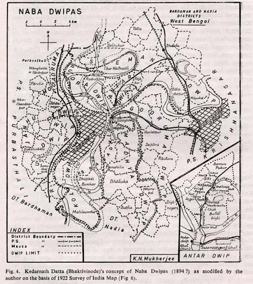
Kedarnath's Navadvipa-dhama Fig. 4 Hunter (1875) / Smythe (1855): Dr. William W. Hunter's Statistical Account of Bengal, Vol.1 (1870-73) is a vast record of authentic information. Colonel H. I. Thueiller's map (1 inch =16 miles) given in Hunter's volume is a generalized one based primarily on the much more detailed maps (1855) of Major R. Smythe's Revenue Survey of 1851-55 (Fig. 5).
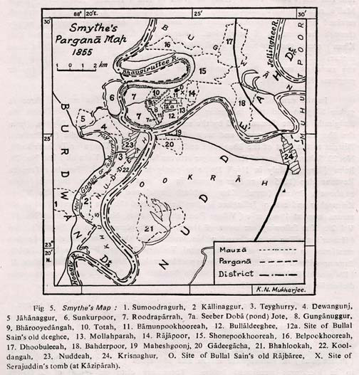
Nadia Bengal Map 1875 of Smythe Fig. 5 Although Smythe's maps gave all the place and river names in acute anglicized form, Hunter gave throughout his report all local terms in correct spelling with dictions for proper pronunciation. By his care and judgment Hunter blazed a new trail in historical cartographical noting and mapping, which unfortunately was not followed fully by quite a few conservative British and anglicized Indian officers of the Survey of India and the railways. Dr. H. Blochmann's geographical and historical notes at the end of the above account included a complete list of Sarkars and Mahals of Todar. Mall's rent-roll Asl-i-Jama Tumar (1552) as given in Ain-i-Akbari. Historically, Todar Mall's rent-roll were subsequently modified by Shah Suja, whose own rent-roll retained largely the previous Sarkars and Mahals, but the number increased mainly through the extension of jurisdiction. Later in 1772 Jaffar Ali Khan (Murshid Kuli Khan) recast the rent-roll as Jama-i-Kamil Tumar in which he redemarcated some Sarkars and divided into Chaklas and introduced the term Pargana meaning practically the same as Mahal. But in some cases a Mahal was subdivided into smaller parganas (Hunter 1875). In the case of old Navadvipa area, Blochmann listed five Mahals, three in sarkar Satgaon and two in sakar Sulaimanabad, viz. No.4 Ukhra (from the Bhagirathi to the Jamuna and by the south of the Jalangi), No. 17 Bagwan (from the Bhagirathi to the north and west of the Jalangi), No. 47 Nadia (in Bardwan District to the west of the Bhagirathi and east of the Mori Ganga or Tegharir Kol), No. 20 Sultanpur (east of Krishnanagar between Icchamati and Kabatak), and No.29 Baira (large, mainly in Hugi Dt. Also partly in Nadia Dt), Smythe's Pargana Revenue Map (1855) gives four parganas in the area (Fig.5) viz. Bugwan (same as above), Ookrah (same), Khus Nuddeah (same) and Muhutpour (by the NE of Krishnanagar and east of Jellinghee). Smythe presented the area in great detail in his mauza maps at 4 inches =1 mile (Village Plans and Traverses, Nuddiah Dt. Book No. 18 Vol.2). The following are some of the rivers and places in Smythe's map (Hunter's spelling is mentioned within brackets for the places and rivers he has mentioned in his account): Dewangunj, Teghury (Teghari) Bullaldeeghee (284/14), Bamunpokhooreah (285/9), Shonepookhooreah (Sandanga), Bhaugiruttee R. (Bhagirathi R.) etc. The figures within brackets are Smythe's and present jurisdiction list numbers (J.L. No.) of mauzas. In Smythe's map the loop in the Bhagirathi (Ganga) by the Belpukur village is still having the main flow, while the old course of the Ganga (Mori Ganga or Tegharir Kol) has become leaner than in Rennell's map, although still maintaining a trickling link with the main channels on both the ends. Three most significant locations in Smythe's map are Ballal Sena's Digi in Ballaldighi mauza as referred to in literatures mentioned before. There are clear indications of old Ganga channels in between Bharuidanga (Bharadanga in Rennell) (287/6) / Ganganagar (286/6) and Rudrapara (183/5) mauzas. The Jalangi has left behind well-defined ox-bow lakes in between Bahadurpur and Dhubulia. Hunter in his report clearly mentioned Mayapura (with correct spelling and diction) as Blochmann noted, "The little town of Mayapura (near Bardwan boundary), where I am told the tomb exists of one Maulana Serajuddin who is said to have been the teacher of Hosain Shah, king of Bengal (1494-1552)." It is well known that Serajuddin was Chand kazi and Blochmann's Mayapura was extending from the Ganga (Bardwan boundary) covering on the other side the entire Bamunpukur village i.e. it was the same as old Navadvipa city. Ramachandrapur was not yet shown anywhere. Moreover, Kedarnath Datta was not in the picture at all at that time. Blochmann's observation might have given him the idea later. Survey of India map of 1922: This map based on Topographical Sheet no. 79A/7 and surveyed in 1914-17 shows that both new Navadvipa town and Krishnanagar town have grown considerably as also extended southward, and both are now in Nadia Dt. But the Nadia name of Navadvipa town is still retained (Fig.6), The old Ganga course in the west (Mori Ganga), still trickling in Smythe's map, is now fully detached and forming the western limit of the Nadia Dt. A number of deserted remnants of the course of the Ganga in the east, west and Ballaldighi-Belpukur area are well marked as bils (elongated ponds) and ox-bow lakes. In this map anglicized spelling for some names are still evident. Bharuidanga has been noted here as Baraidanga, Subarnabihar as Sukunobihar Krishnanagar as Krishnagar, Hugli R. as Hooghly R. Mayapura as Meyapur and Pratapnagar as Pratabpur. Bamunpukur, Ballaldighi, Rudrapara, Shrinathpur (Senathpur) and Swarupganj are also shown in this map.
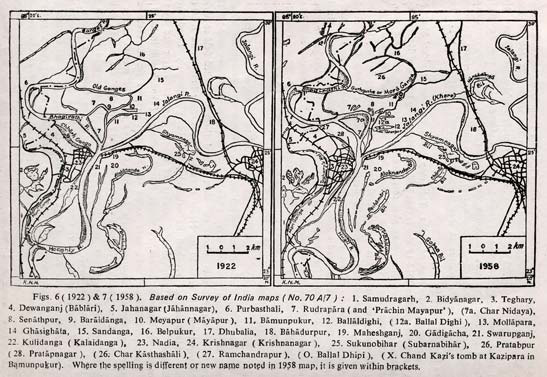
Navadvipa & Krishnanagar 1922 Fig. 6 & 7 Survey of India map of 1958: Of all Survey of India maps, this is the most accurate one (Fig.7) as it was based on fully covered air photographs, supplemented by thorough ground survey (as noted in the foot-note of the map). The rivers, other water bodies, places etc, were named through detailed field enquiries. Navadvipa town still retained its Nadia name and Krishnagar has become Krishnanagar, Mayapura has regained its original name being separately noted from Ballaldighi, and the neighboring locality of Muslim community is noted by the name of Mollapara as before. A village Ramchandrapur (though still included in the Rudrapara Mauza) has been noted to the north west of present Navadvipa town in between the deserted course (Chharh Ganga) and the present course of the Ganga. Char (bank) Nidaya and 'Prachin (old) Mayapur" are noted (within Rudrapara mauza) over the vast island in between the bifurcated channels to the NE of Ramchandrapur. Deserted old courses of the Ganga are shown by the west of Navadvipa as Mori Ganga (or Teghorir Kol) and by the north of Bamanpukur-Mayapura as Mora Ganga is continuing in its trend of changing the course layout. As a matter of fact, the segment of the Ganga by the east and north of Char Nidaya, which dried up totally by 1982 allowing the main flow along the SW channel (by the side of Ramchandrapur), is now considerably revived along with gradual drying up of the westerly one in 1984.
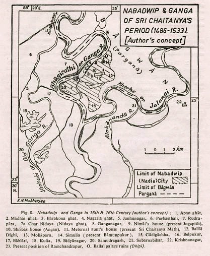
Nabadwip & Ganga Fig. 8 The author being a non-Vaisnavite has no sentimental bias for any of the groups and has squarely rejected from consideration all sorts of emotional imaginary sayings like divine light showing the true place to someone or the appearance of Sri Caitanya in person to another in the late 19th Century. The points detailed above may be summarized as follows: 1. From Rupa Goswami's 8 couplets on the glory of Navadvipa it appears that Navadvipa the place of birth and play of Sri Caitanya, was extended from the beautiful large tank (Dighi) to the Ganga. The maps and records refer to the only dighi in the area and that is the Ballal Dighi in Mayapura (Fig. 8). 2. There is no reference to Mayapura or Nava Dvipas in any contemporary literature or Purana. Navadvipa and Nadia (or Nuddeah or Neddia) were one and the same place, the capital of Bengal of the Sena Kings. At the time of Sri Caitanya it was a forsaken, plundered, desecrated and decaying city. The palace of the Sena Kings (may be belonged earlier to the Buddhist Pala Kings also) is still lying in ruins as Ballal Dhipi near the Dighi (Figs. 4 &7 and Appendix). 3. The tyrant Chand Kazi resided at Kazipara of Simulianagar (in present bamunpukur) of the old Navadvipa City. Through Chand Kazi's tomb there is a massive very old champak flower tree grown, proving the grave to be very old. 4. Muslims in the Kazipara and Mollapara being disturbed by loud kirtana even in the night from Ramchandrapur, more than 6 km away, is absurd, but it could be possible from Mayapura only 1 km away (Figs. 7 & 8). 5. The vivid description of Nimai's (Sri Caitanya) protest kirtana procession from near his residence along the bank of the Ganga to Kazipara, referring to all the bathing ghatas on the way, did not mention Nidaya ghata (opposite Char Nidaya). Nidaya ghata should have been mentioned if the procession started from Ramchandrapur area. But no mention was needed if it started from about the Yogapitha temple in Mayapura, when Nidaya ghata would remain in the opposite direction of Kazipara (Figs. 7 & 8). 6. When Nimai left his house to go to Kantaknagar (Katwa) for his sannyasa, he crossed the Ganga at Nidaya ghata, which is far to the NE of Ramchandrapur in opposite direction of Katwa; Nimai could very well cross over from the ghata near his house at Ramchandrapur (much nearer to Katwa). On the other hand from Yogapitha in Mayapura it was more convenient for Nimai to move westward to Nidaya to go to Katwa (Figs 7 & 8). 7. Even when the first concept of Mayapura and Nava Dvipas were propounded in early 18th Century by Narahari Cakravarti, he vividly described Antardvipa to be in the east and Rudradvipa in the west. But Smythe and other map makers showed Rudrapara (Rudradvipa) to the NE of new Navadvipa city as well as of Ramchandrapur (at the centre of Antardvipa?) and not to the west. Whereas Rudrapara remains definitely to the west of Mayapura, conforming the to the description, while the old Ganga flowed in between the two (Figs. 4 & 7). 8. A very rare genuinely old (500-600 years) idol of Adhoksaja Visnu was found in 1934 buried in the mound at the present site of the Yogapitha temple of Mayapura (Kedarnath Datta died in 1914). Adhoksaja Visnu was described as the family deity of Nimai's house (Fig. 1). It is so rare that neither any such idol was as yet found anywhere else in Navadvipa area, nor was it referred to in any of the historical volumes on Bengal. The idea that somebody kept it concealed from Ramchandrapur for over 400 years to bury it opportunistically at the very place where Yogapitha temple in Mayapura was to be erected is farcical. 9. The author (a pedologist) found the soil in the Mayapura area to be very compact, deep and humus clay, indicating rather old land formation. But in Kankrhar Matha (Ramchandrapur) north of new Navadvipa, in old Ganganagar (Bharuidanga), present Srinathpur (near Gurhgurher Khal) etc, the soil is distinctly layered fine and coarse silt, indicating that the area was in the bed of the river in not too long past. So, original Navadvipa, being a very old city, should have its area to be of hard clay by now (Figs 4 & 8). 10. Smythe's map showed in 1855 Ballal Sen's old Rajbari (palace) in Bamunpukur and Ballal Sen's old Dighi in ballaldighi mauzas (Fig. 4). Hunter's Account mentions definitely (1873) Chand Kazi's (Maulana Serajuddin) tomb being in Mayapura. 11. The 1958 air-photo and thorough ground-survey based map clearly indicates the location of Ramchandrapur to the SW of Rudrapara and Char Nidaya, while Mayapura further to the east of Rudrapara-Nidaya. Both Hunter in 1875 and Survey of India in 1958 referred to Mayapura in its correct spelling and not in the Muslimized form of Meyapur as given only in 1922 edition map. Therefore, the evidences are very heavy in favour of Mayapura centering at Yogapitha area as the place of birth of Sri Caitanya. The author's considered opinion is that every inch of the old Navadvipa City could be considered as the birthplace of the great savant. The author's conception of the location of the old Navadvipa city and the layout of the Ganga at the time of Sri Caitanya (15-16th Century), based on palaeo-fluviometry, is given in Fig. 8. As the old city was extended from Chharh Ganga to Kazipara-Mollapara (Figs. 7 & 8), Ramchandrapur may be considered as part of the old Navadvipa-dhama. Anyone may raise a temple on any area of the old Navadvipa and may tell that his temple is located in the city of birth of Mahaprabhu. As Basak (1981) has rightly stated, there is no point to quarrel over the issue, when Vaisnavas throughout the world are famed for their humbleness. The savant has taught us to love all and his 500th advent anniversary should be celebrated with love. A NOTE In respect of Sri Caitanya's birth and demise several Gregorian dates (Julian too) are in circulation now, although there is no confusion about the Saka dates. Unfortunately, this confusion has developed because of a wrong basis of conversion on the part of many historians and literary critics (historians too). The Saka year starts with the first day of Caitra, which coincides with 22nd March of the Gregorian year (21st March in a leap year) i.e. the day of vernal equinox. The previous Saka month Phalguna ends with 30 days. Moreover, there is a difference of 78 years during the period from Saka newyear's day to Gregorian newyear's day and 79 years from the latter to the former (the Gregorian year remaining ahead of the Saka year). The Julian date on the other hand, is to be advanced by 10 days and the year receded by 46 years (or 45 for the last 10 days of the year) to obtain the Gregorian date. Therefore, if Sri Caitanya was born on the 23rd Phalguna of 1407 Saka (the date accepted by all), then as the difference (backward) is 8 days from 1st Caitra, so 8 days backward from 22nd March was 14th March of (1407+79) 1486 A.D., which was Wednesday according to astronomical calendar. It was a full moon and Holi Festival day with lunar eclipse. The demise of Sri Caitanya is shrouded in mystery and no definite date has been noted. The largely accepted date was 31st Asarh of 1455 Saka (Majumdar 1959). So, with a difference of 78 years the Gregorian year was 1533 A.D. Asarh 31 was 123 days from the beginning of the Saka year (Caitra 30 days and Vaisakha Jyoistha, Asarh each 31 days), so 123 days on and from 22nd March was 22nd July, which was again a Wednesday. The 500th year of birth will start from Thursday the 7th March 1985 (16th Phalguna 1906 Saka and 23rd Phalguna 1391 Bengali year--the Holi Festival day) and will conclude on the pre-Holi Festival day next year. The Navadvipa almanacs with Gaura era (Gaurabda or Caitanyabda) in circulation amongst Vaisnavas (said to have been initiated by Kedarnath Datta around 1844) are now recording one year less in calculation. According to prevailing practice the number of year is calculated on the basis of Tyakta Varsa or Gatabda (the year that has been left behind or that has passed) and not on the basis of Gamyabda (the year that is continuing); although it is admitted that when the 1st year as recorded in the almanac, it was actually the continuing second year. So, according to this calculation the 500th year will be celebrated in the 499th Gaurabda of the almanac. There too, another day is advanced, as the year starts on and from the Anandotsava day i.e., the day after Holi (Pratipada) and ends on the Holi Festival day (Paurnamasi or full month), the birthday of Sri Caitanya, next year. ACKNOWLEDGEMENT The author is obliged to all those followers of Vaisnava faith and others who helped unreservedly in his quest for truth since 1978. Special mention may be made of Principal Caitanya-carana Goswami of Navadvipa Vidyasagar College, inmates of Navadvipa Samajbari Asrama, Srimad Bhakti Kusum Sramana Maharaja--late President-Acarya of Sri Caitanya Matha at Mayapura, Srimad B.B. Sajjana Maharaja, present acarya Sripada Bhakti Prajnana Yati Maharaja, historian Sri Sudhir Kumar Mitra and West Bengal Land Records Office at Gopalnagar, Calcutta. He is grateful to Dr. S. C. Mukhopadhyay, Honorary Editor of this reputed journal. Special mention is also needed to be made of the excellent reference facilities obtained from the classical library of Sri Caitanya Research Institute and Bandhab Samity Text-book Library both at Rashbehari Avenue, Calcutta-26, National Atlas & Theamatic Mapping Organisation's map library at Calcutta and the map library of the Geography Department of the University of Calcutta. The author is deeply indebted to the authorities of these institutions/organizations. APPENDIX From Vrndavana Dasa (Sri Caitanya-bhagavata, Madhya Sec., Ch. 23, 101-105): ek dina daibe kazi sei pathe jaya "One day the Kazi happened to pass along that road (in front of Srivasa Angana) when he heard loud kirtana in chorus with drums, cymbals and conch. He became furious and remembered his own religious sermons. He started beating whomever he could catch, broke the drums and urinated on the door-step." (Mandira - smaller cup shaped cymbal). From Krsnadasa Kaviraja (Caitanya-caritamrta, Adi Sec., Ch. 17, 123-125): mrdanga karatala sankirtana mahadhvani "There was all around the great chorus of drum, cymbal and kirtana, and this loud chanting of God's name drowned all other sound in the area. The Yavanas (Muslims in the neighbourhood hearing this loud kirtana by the Hindus became very angry, went to the Kazi and complained. Being infuriated the Kazi came to the house (Srivasa Angana) in the evening and breaking the drums he ordered all (not to do kirtana any more)." REFERENCES Bagchi, K. & Mukherjee, K. N., 1978: Diagnostic Survey of Deltaic West Bengal. Calcutta, pp. 17-37. Banerjee, Asitkumar, 1962: History of Bengali literature, Vol. II (in Bengali). Calcutta, pp.190-481. 1966: Do, Vol. III, pp. 1070-82. Basak Kartick, 1981: Gauranga and Gauth environ (in Bengali). Navadvipa, pp. 108-109. Bharadwaj, Banarasinath, 1989: An undiscovered literary genious--Kedarnath Datta, Sri Caitanya Res. Inst., Silver Jub. Res. Publication, Calcutta. Chatterjee, Satkari, 1915: Biography of Bhaktivinoda (in Bengali). Published by Bangiya Sahitya Parishad, Calcutta, pp. 1-17. Dasa, Vrndavana, 1548 (?): Sri Caitanya-bhagavata (in Bengali). Ed. B.S. Sarasvati (1965), Sri Caitanya Matha, Mayapur, pp. 298-348. Dasa, Mahaprabhu, 1973: True birthplace of Sri Gauranga (in Bengali). Navadvipa, pp.1-103. Datta, Kedarnath (Bhaktivinoda Thakura), 1893: Navadvipa-dhama Mahatmya, Pramana-khanda (in Bengali/Sanskrit). Goswami, Bhakti Saranga (Ed.), 1959: Sri Stava-kalpadruma (a collection of hymns in Sanskrit). Mathura, pp. 735-36. Hunter, W.W., 1875: Statistical Account of Bengal, Vol. I London, pp.356-72. Kaviraja, Krsnadasa, 1595(?): Sri Caitanya-caritamrta (in Bengali and Sanskrit). Sri Caitanya Matha edition, Mayapur, pp. 719-21. Majumdar, Bimanbehari, 1959: Materials for Sri Caitanya's biography (in Bengali), Calcutta, pp. 4-6 Mukherjee, K.N., 1981: Nava Dvipas--land and people. Golden Jub. Vol., Bhaktivinoda Inste., Mayapura, pp.1-7 Et al, 1982: Comprehensive water pollution survey and studies of Ganga basin in West Bengal. Central Board for the Prevention & Control of Water Pollution, New Delhi, pp. 1-52. 1984: Application of cartographic techniques in presenting inter-disciplinary subjects. Geographical Mosaic, Ed. By S.C. Mukhopadhyay, Calcutta, pp. 289-94. Smith, Vincent A., 1962: Oxford student's history of India. Revised by H.G. Rawlinson, London, pp. 98-106, 143-44 Vidyaratna, Paramananda, 1976: Shrila Bhaktivinoda Thakur (in Bengali), Mayapura. Pp. 7-22 Professor K. N. Mukerjee is the retired head of the Department of Geography, City College, Calcutta; retired lecturer of the Department of Geography, University of Calcutta; Secretary of ILEE and Director of the Research Cell of Sri Caitanya Research Institute, Calcutta.
| |