
|
|
|
|
BY: SUN STAFF
Ancient Indus river system Jul 17, 2020 — CANADA (SUN) — Sri Caitanya's transcendental pastimes with rivers.
India's Ancient River Systems
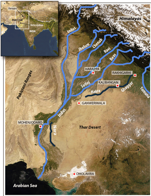
Before we continue discussing some of the holy rivers in the north that are associated with Lord Caitanya's lila pastimes, we would like to mention some general history of India's ancient rivers. The great Indus River system once supported a civilization that populated over a one million square mile area, from the Himalayas to the Ganges delta, and from the plains of the Indus River valley to the Arabian Sea.
Although some of the ancient rivers flowing down over these lands have now disappeared -- most notably the holy Sarasvati -- many of the smaller rivers we'll mention in this series were once tributaries of the ancient waterways.
In his article, "An Ecological View of Ancient India", Dr. David Frawley describes the ancient Indian river system as the "largest and most ideal river region in the world for developing civilization".
"India… had a massive nexus of numerous great rivers from the Indus in the West to the swamplands of the Gangetic delta in the East. It had both a warm subtropical climate and seasonal abundant rains. This river region included relatively dry regions of the northwest to the very wet regions of eastern India affording an abundance of crops both in type and quantity.
The Indian river system was much larger in size and arable land, and better in climate than perhaps all the other three river regions put together. No other region of the world could so easily serve to create an agricultural diversity or the cultural richness that would go with it.
Ecologically speaking, north India was the ideal place in the world for the development of a riverine civilization via agriculture. Bounded by the Himalayas in the north, and mountains on the West, East and South, this north Indian river plain is a specific geographical region and ecosystem, whose natural boundaries could easily serve to create and hold together a great civilization. It was also ideal for producing large populations that depend upon agriculture for their sustenance.
This same network of rivers was ideal for communication. Not surprisingly, the Rig Veda, the oldest book of the region, is full of praise for the numerous great rivers of the region, the foremost of which in early ancient times was the Sarasvati, which flowed east of the Yamuna into the Rann of Kachchh, creating an unbroken set of fertile rivers from the Punjab to Bengal."
Frawley describes the great Indian river system of the north, from the Punjab to Bihar, as perhaps the world's greatest agricultural center. "The type of civilization developed in the rivers of north India could easily connect with the cultures developing on the rivers in the south of the country that shared a common climate and geographical ties. The other main great river region for India is the basins of the Krishna and Godavari rivers in the southeast of India, particularly Andhra Pradesh. This provides another important agricultural center in the ancient world, which has also not been examined properly.
Another important river area is the Narmada and Tapti rivers in Gujarat and Maharashtra. As these were nearby the delta of the Sarasvati, they could have been an extension of it (which is perhaps why the Bhrigu Rishis of this region are so important in Vedic literature)."
| |